Showing posts with label Mollepata. Show all posts

Maps

, In , , , , , , , , , , , , , , , ,

This is a *theoretically* comprehensive list of towns/villages/points along the Salkantay Trek:

Town List 1

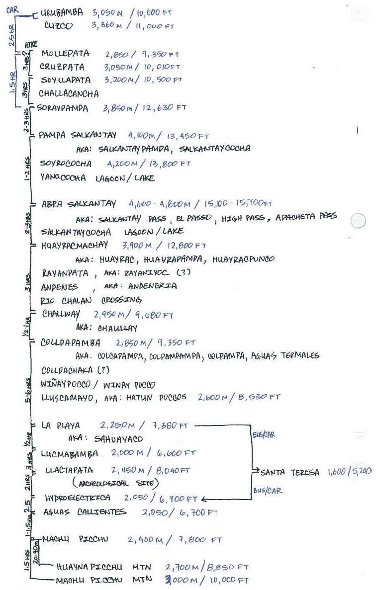
The list above has been combined from various tour itinerary descriptions and maps available online. The travel times are consistent with our experience; however do keep in mind - everyone walks at a different pace.
-----------------------------------------------------------------------------------

The one single thing I wish I had during our travels is a GPS, so I will have to resort to records of others for a true visual of the Salkantay Trek to accompany our blog.

Thanks to "jwheidmeijer" of gpsies.com for his record of the Salkantay Trek:


----------------------------------------------------------------------------
According to other sources this map for $25 includes the full Salkantay Trail GPS trek:
http://gpstravelmaps.com/sacredvalley.php

Some best free maps I found online:

One of the few (if not the only) accurate and mostly comprehensive treks laid out on a scaled, almost topo map. (Follow the left most trek - this is the "Alternative Salkantay"; Inka Trail is on the right):


A minimal representation of the trek on an accurate scaled map:


This map is one of the first results in Google and is pretty good, however note that you should NOT rely on the scale to judge distances, ie: Lucmabamba is actually only ~30 min walk from La Playa while the distance on the map is huge:


 This is a typical map you will find at tour agencies, mostly useless other than examining distances between indicated overnight camping locations:

Getting There

, In , , , , ,

Start:          4:00AM - Urubamba (3,050m / 10,000ft)
End:            8:30AM - Soraypampa (3,850m / 12,600ft)
Via / Time: Taxi / 4.5 hours
Cost:          200 Soles
-----------------------------------------------

There are buses that run from Urubamba to Mollepata (2,800m / 9,200ft). Many tour companies start their hike at Mollepata, however until you get to Soraypampa the route is mostly on drivable roads through villages and small towns, although with very little traffic.
We were recommended to save our legs and a whole day of hiking and skipping this least interesting part of the trek by starting at Soraypampa instead, which is where many tours spend their first night.

In order to get past Mollepata you must take a taxi. We took a taxi directly from Urubamba (where we stayed) in order to start the hike as early in the morning as possible. You must arrange this with a taxi driver ahead of time as the trip starts very early in the morning, it is long, difficult, and requires 4-wheel drive. This can be done by going to the main bus/taxi stop, asking around, and exchanging contact information. Make sure to confirm your ride the night before.

The taxi cost us 200 Soles, which is not bad, considering the distance and road conditions. (Price from Cuzco should be approximately the same, if you look at the relative locations on the map). The route starts with a highway and includes a 4 Soles toll. After reaching Mollepata you will start winding uphill on a dirt/gravel path. Eventually you reach remote villages; the road here becomes very rocky and hopefully you won't lose a muffler or anything worse along the way; the route splits and twists many times and your driver will most likely have to ask for directions.

After about 4.5-5 hours you will reach a large farm field with only mountains ahead. Hike on!


NOTE: We heard that horses can be rented at Mollepata. This could present a couple of adventurous options - either taking horses up to Soraypampa and hiking from there; or potentially taking them all the way up the trek with you - this way you avoid carrying a heavy load but still not going with a group tour. We haven't explored these possibilities, but please let us know your experiences!