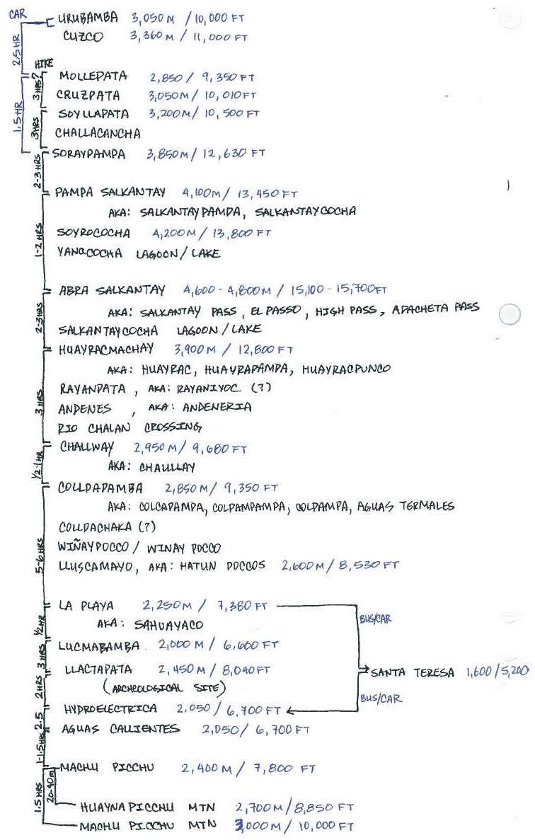
Start: 09:15 - Collpapampa (2,850m / 9,400ft)
End: 15:30 - La Playa (2,050-2,400m / 6,700-7,900ft)
Hike: Slight ascent in the beginning followed by a descent the rest of the day.
Trail splits in many directions and soon becomes a drivable roadway - ask directions.
Stay to the left of the river valley to remain on the trail to La Playa.
The right side of the river has a parallel drivable road that will lead you to the
same destination.
----------------------------------------------
09:15 Collpapampa (2,850m / 9,400ft)
The tropical fauna has certainly shown itself this morning. Avoid the tiny flies that are most active between 9AM and 11AM in the morning, and 4PM to 6PM in the evening. The little suckers surround you like a cloud and bite hard, leaving you very very VERY itchy. This is your best motivation to not hang out around the campsite for too long and start your hike early.
Past Collpapampa the region becomes more populated and the trail splits in many directions. Your best bet is to leave with a tour group and follow them for the first ~hour until you reach the main trail. Otherwise - ask for directions several times along the route, but be aware that you will not encounter many people after 9AM.
- As you leave the campsite you will cross a bridge over a small river. Turn RIGHT immediately after the bridge to head DOWN below it.
On the bridge
Under the bridge
- Follow the trail until it becomes a drivable width road; here it will fork in two directions - keep RIGHT.
Looking forward toward the fork in the path - keep right
- Stay on the wide road switchbacks down along the hillside; do not take the small trail spurs.
Looking forward at the road leading downhill
- Ahead to your right you will see a gondola river crossing and possibly a large market on the other side.
-
Right River Bank: Here we followed the main road to the crossing, took the fun gondola ride over the chasm below and headed straight on the main road along the right river bank. This road will lead you to La Playa. If you want you can hitch a ride with a local car passing by.
What the right river bank roadway looks like
-
Left River Bank: There are trails before and after the gondola that will take you downhill to the river where you will have the option to walk along the left bank of the river. This is the actual trail that the tour groups take. You will avoid dust from road traffic (although in ~5 hours of hiking we encountered a total of 3 cars) and the trail offers a lot more shade.
Can see the trail on top of the left river bank
And now... the following is proudly presented to you by.......... ok, if this beautiful sketch confuses you more than it helps, please feel free to ignore!
*
The description below follows the right river bank *
- Passion fruit trees offered a yummy snack along the way. I am fairly sure that these are on private property, so be discrete :)
- Be ready to cross a freezing mountain waterfall along this path. If you are barefoot - the rocks are sharp but bearable. This was a very welcome refresher for our tired sweaty feet!
15:30 La Playa (2,050-2,400m / 6,700-7,900ft)
After about 6 hours of hiking this day you will see a very large town (it's all relative) sprawl out ahead of you on the left river bank - you have reached La Playa. If you are on the right river bank you will reach the end of the town before you cross the river.
--------------------------------------------------------------------
From here you have two options how to spend the next day:
OPTION 1) Catch a collectivo from La Playa to Santa Theresa, soak your achy self in the thermal springs and spend the night; catch a morning bus to Hydro Electrica; hike 2.5 hours to Aguas Callientes.
This was our route, described next as "
Day 4".
OPTION 2) Camp at La Playa or continue hiking another 30 minutes along the main road (right river bank) to the next town of Lucmabamba and spend the night; next day up-and-down 3 hour hike to the ruins of Llactapata, another 2 hrs down to Hydro Electrica, and either hike 2.5 hrs or catch a 4PM train to Aguas Callientes.
This route is described from comments of people we've met along the trek as "
Day 4*".
---------------------------------------------------------------------
16:30?
Santa Teresa (2,050-2,400m / 6,700-7,900ft)
We stayed at a campground in the back of a private house.
Among a couple of dogs, and an affectionate black cat, one of the cutest household members is a monkey named Poncho.
Again, be aware of the evening and morning biting flies here.
Santa Teresa is a developing town mostly catered to passing by tourists. The thermal springs are certainly worth visiting after 3 days of hiking. There are many restaurants and at least one "very American" dance bar - if you are into that.